Beatrice Maria Rosso (Notre Dame)
Dante Notes / June 29, 2026
Dante Atlas Network: https://danteatlas.org
The Divine Comedy is profoundly structured by geography. Yet in the classroom, the spatial dimension of Dante’s poem often remains abstract, due to time constraints and the obscurity that some lesser-known places can create for students not too familiar with them. This essay presents the Dante Atlas Network (DAN), a collaborative digital mapping project designed to position geography as a central interpretive framework that attempts an interdisciplinary approach. On the map, literature, history, and geography come together to explain the same story.
What DAN is
DAN is an interactive website and teaching tool where students write posts about assigned locations in Dante’s Divine Comedy, exploring and interpreting the role of geographical elements in the poem. Students’ contributions are currently live on a public website (danteatlas.org), and those who want to have their names displayed are listed in the “Contributors” section.
DAN’s origin story
Developed in the context of Professor Theodore J. Cachey’s undergraduate course on the Purgatorio and Paradiso at the University of Notre Dame, DAN has been designed to address two problems associated with teaching the Comedy in the classroom (and the project benefited from Professor Cachey’s guidance on the assignment’s pedagogical objectives). Firstly, due to the fast pace required to cover two canticles in almost their entirety (66 cantos in 26-28 meetings), there is not enough time to engage with secondary literature extensively. Secondly, more conventional exercises, such as summaries of academic articles, can easily be produced with AI tools with relatively little engagement on the part of the student. DAN was designed to encourage a different form of work: students must connect close reading, geographical research, and interpretation within a shared digital project. While the assignment does not eliminate the possibility of AI-assisted work, it shifts the emphasis from reproducing information to contributing to a collaborative and publicly visible resource. The limitations of the pilot’s approach, as well as possible improvements on the AI policy, are discussed below.
The assignment
Here are the instructions as they appeared in Professor Cachey’s “Dante II” syllabus for Spring 2026. The students were assigned two different locations, one from Purgatorio and one from Paradiso. They were asked to submit them before spring break (mid-March) and before the end of the semester (end of April). The two posts were worth 10% of the final grade combined.
Map Post instructions
Objective: The Divine Comedy incorporates multiple real-world locations throughout the poem. This semester, we will collaborate to visualize Dante’s world by mapping these references on a shared Google Map.
Your Assignment: You will be assigned two geographical locations: one found in Purgatorio and one in Paradiso. You must create a map entry for each location.
Instructions:
1. Locate your text: Check the List to see which Cantos mention your assigned locations. Do a close reading of those specific passages.
2. Pin the location: Go to the shared Google Map. Search for the real-world location and drop a pin.
3. Write your analysis: In the description box of the pin (or the assigned submission platform), write a 300-word entry relating the Canto to the geography. You should use Hollander commentary and at least one commentary from the Dartmouth Dante Project.
Content Guidelines:
Your entry must address the following:
● Context: Where are the characters physically standing in the afterlife when this real-world location is mentioned?
● Action: Who is speaking? What is the conversation or event taking place?
● Significance: Why does Dante mention this specific place? How does the real-world geography connect to the symbolic or thematic meaning of the passage?
In the pilot, the map posts were read and corrected by me, mostly if they presented big mistakes, but not in the form or style, nor did I add or point out topics that might have been included. Because this was a pilot implementation, all students who completed the assignment requirements received full credit.
How it was developed
The first step was to find an accessible, free platform that would allow a significant number of users to place pins on a map and edit them simultaneously. After evaluating several options, Google My Maps was selected because it is already integrated into the University of Notre Dame's digital infrastructure and could be easily embedded into a public website.
An initial attempt to generate the website using free AI-based web design platforms proved unsatisfactory, both in terms of output quality and the very limited control and possibility to edit the final result. These tools typically rely on platforms that do not allow full control over the website’s code. For this reason, I chose instead to build the website from scratch, using AI as a support tool to refine and generate portions of the HTML.
A fundamental part of the development on the different pages was the addition of the “Contributors” and “Resources” pages. Students who wish, after written agreement, to have their names up on the website can currently be found both next to their specific locations and generally listed under “Contributors.”
This experiment demonstrates that the spatial dimension of the Divine Comedy can function not merely as contextual background but as a primary interpretive framework through which students engage with the text. It also shows the value of designing alternative assignments that go beyond traditional formats and incorporate interactive, visual, and collaborative elements. Working on a shared, digital, and publicly accessible platform changes the way students approach their work: not only do they complete an assignment, but they also become part of a live, online project. In this sense, the project is not only a response to the presence of AI in the classroom but also an opportunity to investigate how students use such tools within a collaborative, research-based assignment. The project was not designed to prevent the use of AI altogether, nor does it teach students how to use AI tools responsibly. Rather, the idea was to move away from assignments that can be completed as isolated written exercises and toward a collaborative, visual, and publicly accessible project. Students are not simply submitting a text to an instructor; they are contributing to a shared map that can be explored by their classmates and by visitors to the website. Whether this ultimately changes how students use AI remains an open question, and one of the issues currently under investigation.
Challenges and Future Directions
The pilot version of DAN revealed a few areas that need further thought, as well as many opportunities.
The first question concerns the quality and curation of published content. During the pilot, all submissions that met the assignment requirements were published on the website. In future reiteration of the assignment, it will eventually be necessary to develop editorial guidelines or review procedures to ensure consistency. Encouraging an initial peer-review system followed by an instructor assessment can be a starting point for future practice.
Beyond questions of assessment and curation, the future growth of DAN includes the question of the map's size. In the long run, the objective is to continue expanding the map until all geographical references from the Divine Comedy have been added. However, as DAN grows, some thought will need to go into how to handle places mentioned multiple times throughout the poem, such as Florence, as well as how to effectively portray them on the map. Further possibilities for future work could include building other thematic maps, such as a historical one focusing on notable people and events (like Montecatini and Campaldino) from the Divine Comedy.
From a practical perspective, DAN currently operates on a minimal budget that meets the project's needs and the time available to the person running it. However, if participation continues to grow, more sophisticated mapping tools, such as ArcGIS, or customized mapping solutions with additional interactive features may become worth considering.
One challenge concerns the role of AI in the completion of assignments. While the project was designed as an alternative to easily generated “older” assignments, it does not eliminate the possibility of AI-assisted (or even largely generated) work. In the pilot, we deliberately chose to stick to the AI policy in the syllabus, without stressing it too much, as we were interested in understanding how students used these tools and how they perceived the public nature of the assignment. More broadly, the question of whether this type of assignment promotes deeper engagement with the text remains open. Do students still use AI to complete their posts? Or rather, how are students still using AI? Is the use of AI in this particular setting enhancing their learning? If yes, how and why? I am currently running an IRB-approved questionnaire under the guidance of Prof. Tessa Gurney, Coordinator of Italian at Notre Dame, and Prof. Katie Boyle, Associate Director of Undergraduate Studies at the same institution. We hope to share our findings once we collect and analyze the data.
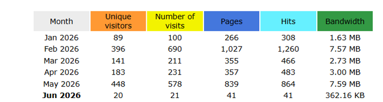
Even if DAN was always meant to be a strictly pedagogical tool, it is still worth looking at its reach beyond the classroom. Website data offers a useful perspective on how the Dante Atlas Network has developed over time. Since its publication in January 2026, the project has recorded a total of 1277 unique visitors and 1,831 visits, with 2,885 hits overall. (Data as of June 2nd, 2026; source: Reclaim Hosting statistics for danteatlas.org.) While these numbers remain modest, they indicate a steady level of engagement and suggest that the project is not confined to the classroom but has begun to circulate more broadly.

![]()
Data collected as of the date of writing (June 2nd, 2026).
More broadly, DAN suggests the value of rethinking traditional assignments through multidisciplinary, visual, and collaborative approaches. Because geography was already a central interpretive framework in Professor Cachey’s “Dante II” course, the project extends classroom discussions by making Dante’s (and our) world visible and interactive. In doing so, it encourages students not only to read the Commedia, but also to actively construct knowledge about it.